“The sea has never been man’s friend. At most it has been an accomplice of his restlessness”. (Jose Conrado)
And to alleviate some of that concern that Conrado talks about, in today’s post we bring you a list of top nautical apps 2024, essential if you are a lover of the sea and sailing As you know, we are all about recreational sailing, so that’s what we are going to focus on: recommending the apps we like the most. We exclude, therefore, the apps for fishing, regattas, etc.Make yourself comfortable and get your phone ready to start!
Selection criteria
Modern navigation has been transformed by nautical apps, which have become essential, accurate and advanced tools. But in the vast ocean that is the Play Store or its equal the Apple Store, separating what is worthwhile from what is not is sometimes no easy task. To select the apps in this article, we have taken into account different criteria such as: usability, the features of each application, user ratings, and proper functioning. In addition, we have classified them according to their subject, to make it easier to find the app you need. That said, let’s get to our top nautical apps 2024.
Top Nautical Apps 2024
Nautical weather apps
We begin the list with some of the most important applications for navigation, which are those that allow us to see the weather forecast. Bear in mind that all of them only work if you have an internet connection. In any case, our recommendation is always to check the weather forecast before leaving home, not once in port. And the most sensible thing to do is to change the date if the conditions are not going to be favourable.
Nombre de la App: Windy
Descripción General: Esta es una de las apps más usadas en el mundo para la previsión del tiempo en el mar y para la navegación. Se centra en el pronóstico de los vientos en los próximos 10 días, por eso se ha convertido en uno de los software más descargados entre quienes practican surf, windsurf y kitesurf. Te permite ver la previsión del viento sobre un mapa animado, con escala de colores y animación para la dirección, tanto de viento como de olas, que es lo más importante para planificar la navegación. Da la previsión de lluvias, tormentas eléctricas, temperatura, nubes, calidad del aire, nieve, humedad, niebla, rayos UV, visibilidad, corrientes marinas, etc. Es una aplicación gratuita bastante completa.
Nombre de la App: Windguru
Descripción General: App meteorológica muy buena para la navegación gratuita. No da tantos parámetros como la anterior, pero para la previsión del viento ofrece un mayor detalle. También permite ver el viento en el mapa animado con escala de colores. Se centra en el viento, pero nos da también la previsión de las olas, la precipitación, temperatura y nubosidad. Además, esta app tiene diferentes fuentes que al compararlas todas da una idea mucho más fiable de la previsión real.
App Name: Rain Alarm
General Description: Another very popular app among sailing enthusiasts, although it only offers information about the possible rainfall that may occur in the position where we are.
Name of the App: Marítima Meteoconsult
General Description: An app that provides constantly updated information and complete weather forecasts for land and sea. It also includes very specific anchorages, beaches and harbours, as well as the state of the tides, winds and rainfall.
App Name: Weatherpro HD
General Description: Best of all, it works in real time, offers satellite imagery and displays weather for the next seven days, in three-hour intervals and for more than two million locations worldwide.
Nautical applications on navigation and geolocation
Name of the App: Salvamento Marítimo SafeTRX
General Description: Monitors the vessel’s voyages, alerts the contacts chosen by the user when there are delays in the planned voyage, and provides a web page so that Maritime Rescue can quickly consult the route taken by the vessel and take appropriate action. To make it work, the navigation plan data must be entered and the vessel sets sail. The app is responsible for sending the reference of its location to the system from time to time and in this way Maritime Rescue can know the position of the vessel at all times. In the event of not arriving at the destination at the scheduled time, it automatically sends an alert to the contact set, so it is important to modify the estimated time of arrival if necessary to avoid false alarms.
App Name: Boating by Navionics
General Description: This app makes it easy to know your position, real speed, log your route, plan your trip, measure distances between two points, and always know the distance to shore. It also provides up-to-date information on tides, currents, wind forecast, solar and lunar cycles. Navionics Boating offers a vast database of maritime points of interest with geotagged photos and videos, and allows you to synchronise routes and tracks between different mobile devices from anywhere. You can use the app without a wifi connection by downloading maps of the area of interest in advance. Although many features do not require an internet connection, the device must have a GPS chip.
Nautical applications for safe anchoring
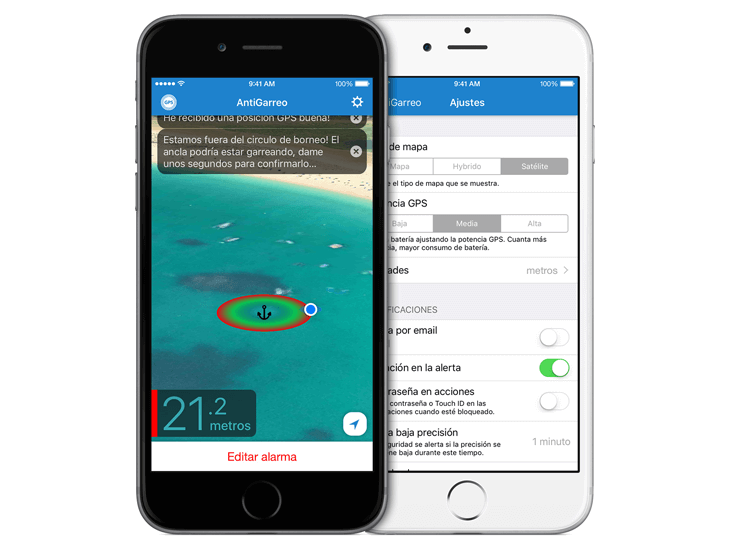
App Name: AntiGarreo
General Description: Developed by marinus.com this app stands guard and warns you in case your anchor is not securely attached and your boat is dragging. Once anchored, activate ‘AntiDragging’. Once configured, you will see on the screen the map with the location of the anchor, the borneo circle and the boat with its tracking. No internet connection is required (except for email alerts). AnmtiGarreo is not available for Android but there are other similar apps such as ActiveCaptain, AnchorAlarm etc.

Image source: marinus.es
Other nautical Apps of interest
App Name: Shoreview
General Description: It is the Google Maps of the sea. While sailing you can see what the coast and the sea have to offer in real time. The app becomes a pioneering visual assistant that offers a new way of observing the coast. In addition, and in this it is similar to Waze on land, the application has a community of sailors who provide information in real time, creating hazard alerts for sailors. Alerts such as floating objects, coast guard, divers, boat traffic, currents and others such as jellyfish or advice on the interests of swimmers are created daily on this collaborative app.
Conclusions
Modern boating has been transformed and made amazingly easier by nautical apps, which have become essential tools. In this article we’ve detailed some of the top boating apps 2024 for their proven effectiveness. These apps, designed for the boating community, offer advanced and accurate tools that redefine the boating experience, facilitating mapping, weather tracking and collaboration between boaters. We’d love to hear from you if you’ve downloaded any of them or if you’re using one that you’re missing from this list.
